The Pacific Crest Trail - The Oldest Successful Thru-Hiker
The Pacific Crest Trail Association does not keep statistics regarding the youngest, oldest, or fastest times for a Pacific Crest Trail thru hiker so we thought it might be fun to attempt to record the oldest of those who successfully complete a thru hike of the PCT.
The PCT covers roughly 2,650 miles with an end or start point in Campo California at the Mexican border, and the other end at the Canadian border, near Manning Park, BC (read more about this below).
A PCT thru hike can be loosely definied as a continuous hike from one end to the other during a single season. Thru hikers are not those who hiked the entire trail over a number of years (which is also a huge accomplishment!)
The normal (South to North) season starts in April and stretches to as late as November, however one can be out of this window and thru hike in the opposite direction (N to S). As a purist, there should be no skips (missing a part), no flips (jumping ahead, then returning for that section later), and no "reverse hiking" (that would be hiking a segment backwards with respect to your normal direction). For this webpage, we are not in the "purist" world and are accepting anyone who completed the trail and registered their successful thru hike with the Pacific Crest Trail Association (PCTA) on their 2600 miler list.
Presently, we can only find information on the oldest man. We are still researching who the oldest woman is. WE NEED YOUR HELP to keep this page updated. If you know of someone older (male or female) who successfully thru hiked the PCT in one season then send us an email with the particulars. We will update this page. email: jack@724network.com Please put "Oldest PCT thru hiker" in the subject line.
The current oldest man:
Al Learned
Trail name "Al"
Completed the trail in 2018
at the age of 81 (and 58 days).
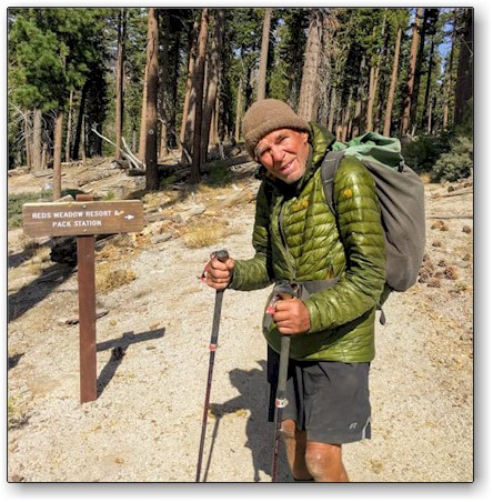
This guy is the real deal, an ultra-badass hiker. More than a triple crowner, Al has a huge resume of long distance hikes. When not hiking, he resides in a log cabin, near Port Townsend, WA
The current oldest woman:
(send info and pictures please, people nominated
should be listed on the 2600 miler list.)
Even if you are not a hiker, you can become a member of the PCTA and support the trail! And, for you hikers: Please practice LNT (leave no trace) and Rule #6 (perform one instance of trail maintenance per day. Kick a pine cone off the trail, pick up trash, move a big rock, whatever)
Trail facts: The Pacific Crest Trail is approximately 2,650 miles long and goes from the Mexican border (fence) at Campo, CA, through California, Oregon and Washington and ends at the US/Canadian border near Manning Park, BC, Canada. Most thru hikers go South to North, starting in Campo sometime in April or May and arriving at the Northern border in September or October.
The trail passes through 24 national forests, 37 wilderness areas, and 7 national parks. It climbs nearly 60 major mountain passes and descends into 19 major canyons and ambles by more than 1,000 lakes. The high point is Forrester Pass at 13,153' and the low point is near sea level at the Columbia River (Cascade Locks, OR).
It was designated a National Scenic Trail in 1968 but not completed until 1993. It takes about 150 days to hike the distance (with about 20-30 non-hiking or "zero" days in the towns). Because of weather considerations, most thru-hikers go from South to North.
There are food resupply points along the way about every 3-9 days. Some hikers pre-mail food boxes to themselves to these points. Others shop at the local grocery store for supplies for the next segment. Those that complete the thru-hike will have climbed up 428,011 feet and descended 426,486 feet (130,000 meters). That is the equivalent of almost 15 ascents of Mt Everest from sea level!
If you are interested in thru hiking the Pacific Crest Trail, learn more here and watch this video.
See even more information including other various records for hiking the PCT
See altitude profiles of the trail sections here